Climate change is escalating urban challenges worldwide, with cities facing more frequent flooding, intensifying heat waves, and loss of biodiversity. As urban populations grow, how cities are planned and built makes a critical difference in their resilience to climate impacts. This article examines two contrasting paradigms: the post-war British New Towns – exemplified by Harlow and Milton Keynes – which intentionally integrated green spaces into urban design, and India’s major cities – Mumbai, Delhi, Hyderabad, Bengaluru, Kolkata, Ahmedabad, Chennai, and Pune – which are grappling with rapid growth, shrinking green cover, and rising climate vulnerabilities. We study the comparison on how British ‘New’ Towns incorporated landscape design for flood mitigation and heat reduction, and evaluate how Indian cities are performing on these fronts in recent years (2020–2025). A special focus is given to the Mumbai Metropolitan Region’s planned expansion, termed “Mumbai 3.0” or Third Mumbai, assessing whether these new town developments are addressing climate change challenges. I will also review relevant Indian urban planning frameworks – from open space reservation norms to flood-line regulations – and conclude with policy recommendations for climate-resilient urban planning in India.
Green Spaces in British New Towns: Landscape Design for Resilience
Britain’s post-war New Towns program (1940s–1970s) offers instructive examples of urban planning that valued green space from the outset. Over a 30-year period – from early New Towns like Harlow (begun 1947) to later ones like Milton Keynes (begun 1967) – planners treated the existing landscape as an integral element of the towns itself. In Harlow, for instance, natural valleys and ridges in the River Stort’s catchment were preserved and woven into the urban fabric. Housing was built on higher ground, while the small valley corridors were retained as parks forming so-called “green wedges” linking the town to the countryside. This green wedge concept not only provided recreational open space but now also serves as a flood mitigation mechanism: those same valleys and parks are being used to alleviate flooding from the Stort River, and they have been replanted to enhance local biodiversity. Such foresight in preserving waterways and open lands within urban neighborhoods created a natural drainage network that modern planners now recognize as a boon for climate resilience.
Milton Keynes, one of the last New Towns, was similarly designed with an extensive green infrastructure. The town features a network of linear parks along the River Ouzel (a tributary of the Ouse) and within a loose grid of roads. These parks and green corridors were intended as amenities, but they double as flood storage and conveyance areas. Today, Milton Keynes’ park network is consciously used to accommodate flooding, allowing excess rainwater to collect in open spaces rather than inundate homes. Moreover, tree-lined streets and generous green buffers were part of the original plan – measures that provide shade and cooling to counter the urban heat island effect. In fact, New Town planners (inspired by the Garden City movement) believed in “soleil, espace, verdure” (sunlight, space, greenery) as essential for healthy living. While they were not explicitly aiming to combat climate change (a then-unknown issue), the emphasis on trees, parks, and open land now yields climate co-benefits: mature urban forests reduce peak summer temperatures and well-placed greens absorb stormwater. Recent initiatives in these towns continue to leverage this legacy – for example, Harlow’s green wedges are being enhanced to improve flood resilience and biodiversity, and new developments around Harlow (the Harlow and Gilston Garden Town project) plan to integrate blue-green infrastructure (parks, wetlands, and sustainable drainage) to manage climate risks. The British New Town experience thus illustrates how landscape-led planning – preserving natural topography, waterways, and green space – can create inherently resilient urban forms that moderate floods and heat. These lessons remain highly relevant as cities today seek models for sustainable growth.
Urban Climate Resilience Challenges in Indian Cities
In contrast to the planned green landscapes of British New Towns, many Indian megacities have expanded rapidly with high-density development and dwindling open spaces, leading to acute climate vulnerabilities. Recent data (2020–2025) paints a concerning picture of urban flooding, heat stress, impervious surface growth, and ecological loss in cities like Mumbai, Delhi, Bengaluru, Chennai and others. Below, we examine key aspects of these challenges:
Urban Flooding: Frequency and Impact
Urban flooding has become alarmingly frequent in India’s cities, driven by extreme rainfall and inadequate drainage compounded by unplanned growth. Major metros that historically saw severe floods only rarely are now inundated almost every monsoon. Delhi, for example, experienced only six major floods in the entire 20th century (1900–1995), but in just the last decade it has suffered five major floods (2013, 2018, 2019, 2021, 2022). Likewise, Chennai – a coastal city prone to cyclones – faced a catastrophic flood in 2015 (with over 200 fatalities) and continues to flood frequently (e.g. December 2023 brought 40 cm of rain in 44 hours, its heaviest downpour in 47 years). Mumbai, Hyderabad, Bengaluru, Ahmedabad, and others have all seen “once-in-a-century” style floods occur in the past few years alone. Recent records include Hyderabad’s inundations in 2020 and 2021, Chennai again in 2021, Bengaluru and Ahmedabad in 2022, massive waterlogging in Delhi in 2023, and even typically dry cities like Nagpur facing flash floods.
The causes of this flooding surge are multi-faceted. Climate change is amplifying extreme rainfall events – India’s average annual rainfall in 2022 was 1,257 mm, up from 1,054 mm a decade earlier. But equally significant are local factors: uncontrolled paving and construction have choked natural drainage and water retention areas. Cities have expanded by paving over lakes, wetlands, and floodplains that once absorbed rain. In Bengaluru, for instance, rapid urbanization has led to a 1028% increase in built-up area between 1973 and 2017, at the cost of 79% of its water bodies being lost or degraded . The city’s famous network of interconnected lakes has been fragmented by encroachment and rampant construction, so when one lake overflows, the excess can no longer flow to the next – resulting in localized floods. Across cities, impervious surfaces (concrete, asphalt, buildings) now dominate, preventing rainwater infiltration. A recent study of three tropical megacities (including Kolkata in India) found that from 2000 to 2020, impervious surface area expanded by 30–40% while green space shrank by 20–40%, leading directly to more runoff and higher urban flood risk. These land use changes mean even moderate rains can overwhelm drains. Additionally, many Indian cities have undersized or poorly maintained stormwater systems. Drains clogged with silt and garbage, along with the lack of proper citywide drainage planning in new growth areas, leave water nowhere to go. The result is routine waterlogging that increasingly crosses into disaster – as seen in Mumbai’s annual monsoon floods or Chennai’s chronic inundation of low-lying neighborhoods.
Urban Heat Islands and Vanishing Green Cover
Indian cities are also heating up. The Urban Heat Island (UHI) effect – where cities are significantly warmer than surrounding rural areas – is intensifying due to loss of tree cover and spread of concrete. Studies across India show UHI intensity (the temperature gap between urban and rural) can range from 2°C up to 10°C on average, and tends to be highest at night as urban structures release stored heat. Rapidly growing metros are particularly vulnerable. Kolkata, for example, saw its average UHI intensity rise by about 1.4°C over the past two decades (2000–2020) as greenery declined. In Mumbai, analysis by the World Resources Institute revealed that by 2018 about 31% of the city’s land area had an average surface temperature above 30.5 °C – a 174% increase in hot coverage compared to 1988. Local micro-climates within cities vary starkly: dense informal settlements with little vegetation can be 5–6 °C hotter than leafier, affluent enclaves in the same city, underscoring how green cover (or its absence) directly affects livability.
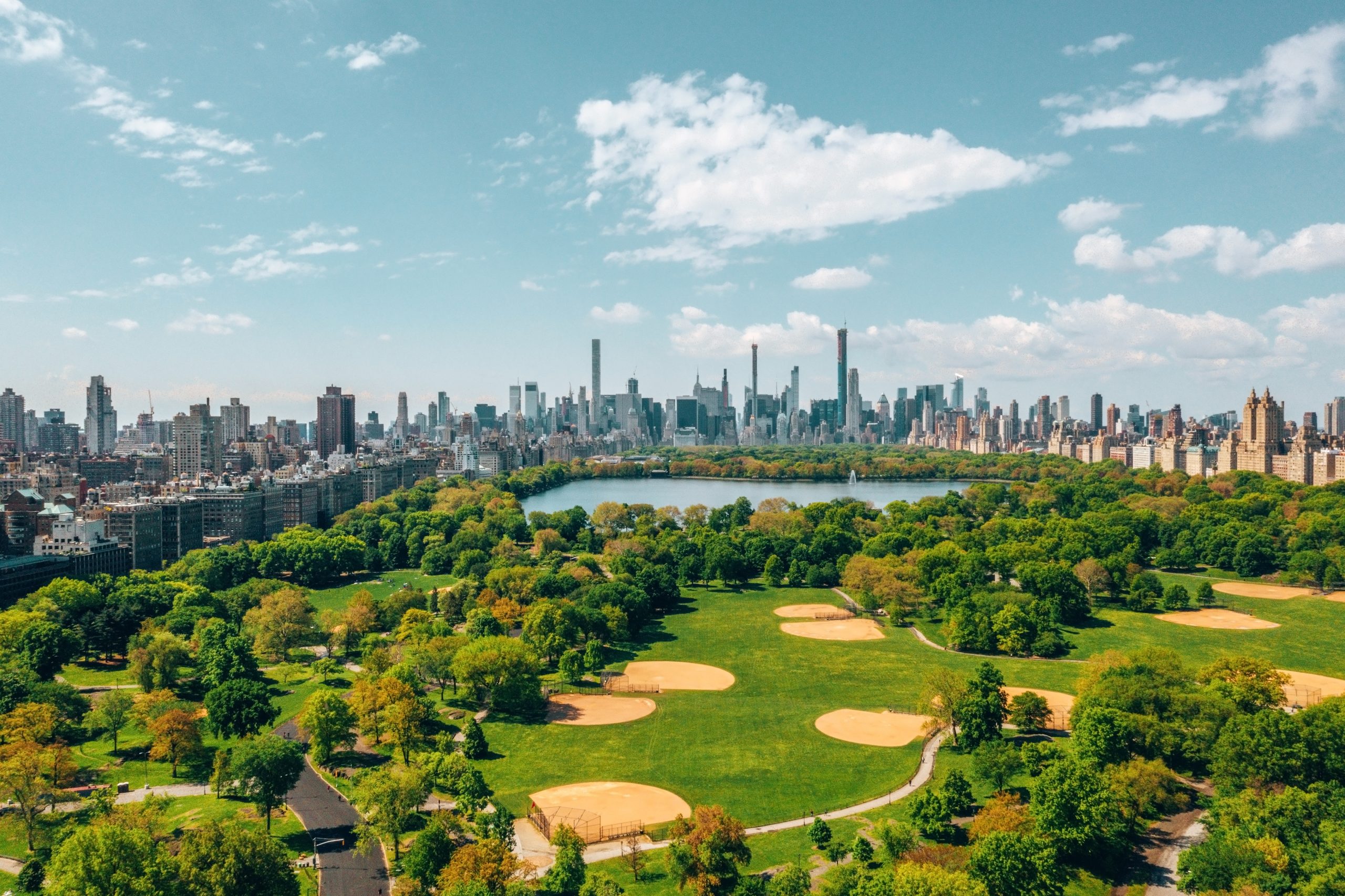
A chief culprit behind these trends is the diminishing green cover in Indian cities. Parks, gardens, and roadside trees have not kept pace with urban sprawl; in many cases they have been victims of it. The World Health Organization recommends 9 m² of green space per city resident, and India’s own Urban Development guidelines (URDPFI) suggest 10–12 m² per person as a norm. In reality, most Indian megacities fall far below this. Mumbai, for instance, has only about 1.08 m² of accessible open space per person, a tiny fraction of the recommended norms. Delhi and Bengaluru fare somewhat better (roughly 20 m² and 17 m² of green space per capita, respectively, when including forests and large parks), yet these averages mask inequalities in distribution and ongoing losses at city fringes. Urban expansions often come at the expense of forest land and wetlands. In Delhi, the spread of suburbs has eaten into the Aravalli hill forests and the Yamuna floodplain. In Bengaluru and Hyderabad, rampant construction have felled thousands of trees along new roads and IT parks. Biodiversity loss accompanies this trend – native lakes, marshes, and green commons that harbored urban wildlife are disappearing, threatening local ecosystems (such as the flamingos of Navi Mumbai’s creek, or the migratory birds of Hyderabad’s vanishing wetlands). Nationally, nearly 40% of India’s wetlands have been lost in the last 30 years, directly affecting cities’ climate resilience. Wetlands and floodplains act as natural sponges for rainwater; their loss has made cities more flood-prone. A stark example is Chennai’s wetland shrinkage – the city lost over 60% of its wetlands between 1980 and 2010. The degradation of Chennai’s marshes (like Pallikaranai) was a key factor that compromised the city’s ability to cope with the 2015 floods, which led to economic losses of roughly ₹10,000 crore as industry was shut for days. Similar stories play out elsewhere: Mumbai’s construction on floodplains and coastal mangroves has reduced buffering capacity against storms, and Bengaluru’s erased lakes mean high runoff and less cooling. The net effect is a vicious cycle – less green space and water bodies lead to hotter, more flood-prone urban environments, which in turn strain infrastructure and public health.
In summary, India’s major cities are experiencing increased climate stresses due to decades of growth that undervalued environmental safeguards. High impervious cover and low green-to-gray ratios have elevated flood risks and urban heat islands to unprecedented levels. Biodiversity and ecosystem services that once moderated urban climates have been severely eroded. The data underscores an urgent need for Indian cities to rethink their development trajectory and integrate green resilience into urban planning – a theme we explore further in subsequent sections.
Policy and Planning Frameworks in India: Gaps and Opportunities
The challenges above highlight that Indian cities’ climate vulnerabilities are as much a result of policy and planning choices as they are of natural forces. This section reviews some key legal and planning frameworks governing urban development in India – including Urban Development Department (UDD) policies, open space norms, and flood zone regulations – to assess how well they address (or could address) climate resilience.
Open Space and Green Cover Norms: Urban planning guidelines in India do acknowledge the importance of open spaces. The Ministry of Urban Development’s URDPFI Guidelines (Urban and Regional Development Plans Formulation and Implementation) recommend 10–12 square meters of open space per person in cities, which aligns with international norms. Many city Master Plans and Development Control Regulations stipulate that a certain percentage of land in new layouts be reserved as open or green space. For example, it’s common for municipal by-laws to require 10% of any large residential layout (typically over some acreage threshold) to be dedicated to neighborhood parks/playgrounds. Some states have additional mandates: Maharashtra’s development rules classify “Recreational Grounds (RG)” as a land use that must be provided in city plans, and Delhi’s Master Plan includes minimum green area targets. However, the implementation of these norms has been weak. The case of Mumbai’s 1.08 m² per capita open space (versus 10+ m² norm) is illustrative – despite policies on paper, in practice the city accumulated a huge deficit of public parks. Rapid population growth and expensive land markets led to open space provisions being ignored or waived. Enforcement issues have undermined the intent of open space norms. On a positive note, awareness is rising: cities like Mumbai are now drafting Climate Action Plans that explicitly call for increasing urban green cover and even developing a local biodiversity strategy. National missions like the AMRUT (Atal Mission for Rejuvenation and Urban Transformation) include creating and upgrading urban green spaces as a thrust area. Yet, bridging the gap between policy and reality remains a challenge – and one that must be overcome to cool cities and manage floodwaters naturally.
Flood-Line Regulations and Land Use Planning: In principle, urban planning in India does recognize that certain areas are high-risk for flooding and should be kept free of intensive development. Many states delineate flood lines along rivers within cities. For instance, Maharashtra uses a system of “Blue Line” and “Red Line” demarcation for rivers: the blue flood line corresponds to the area likely to be inundated by a 1-in-25-year flood (a moderate flood), and the red flood line marks the extent of a 1-in-100-year flood (a severe flood). By regulation, the zone between the riverbank and the blue line is typically a no-construction zone, meant for either open space, parking or other non-sensitive uses. Areas between the blue and red lines are usually also restricted (often designated as agricultural or open use in development plans) to prevent high-density construction in those flood-prone stretches. Cities like Pune and Mumbai have these flood lines marked in their official plans, and ideally new buildings are not to be approved in those zones. Similarly, planning rules often require buffers along stormwater drains (“nallahs”) to remain clear of encroachment. In practice, however, enforcement again falls short. Many Indian cities have seen extensive encroachment of floodplains – either through informal settlements or even authorized projects when regulations are bent. A striking case is the Yamuna floodplain in Delhi, where despite environmental regulations, large swathes were built over (from slum clusters to even Commonwealth Games Village apartments), reducing the river’s overflow room. In Pune, after severe floods, the authorities recently had to order demolition of dozens of illegal structures that had come up within the Blue Line of rivers. In Mumbai, critical flood-sponges like the Mithi River’s marshland were long treated as dumping grounds and were heavily encroached, contributing to the 2005 flood disaster. There have also been instances of policy regression: for example, the Maharashtra government in 2021 re-zoned certain areas between blue and red flood lines in the Pune region from “No Development” to Residential Zone, effectively opening previously protected floodplain lands for construction. Such moves, driven by urban land pressures, run directly counter to resilience goals. On the regulatory front, the National Disaster Management Authority (NDMA) issued guidelines on urban flooding in 2010, advocating measures like preserving natural drainage channels and creating dedicated Urban Flood Management plans, but uptake by city agencies has been limited. The Smart Cities Mission and Climate Smart Cities initiative under the Ministry of Housing and Urban Affairs encourage cities to map vulnerabilities and invest in drainage, green cover, and water harvesting. Ultimately, the framework is there – laws to restrict building in risky areas, and policies to promote nature-based solutions – but political will and coordination among urban departments (UDDs, municipal bodies, environment authorities) determine outcomes. Stronger inter-agency collaboration and enforcement mechanisms are needed to turn plans into action, especially as climate risks grow.
Recent Innovations and Examples: Some Indian cities have begun to incorporate resilience in planning. Kochi and Mumbai, for example, have explored the concept of “sponge cities” – adopting techniques like permeable pavements, rain gardens, and restoration of canals to absorb rainwater. There is also movement on restoring urban ecosystems: Chennai’s government and NGOs are working to restore parts of the Pallikaranai marsh and create micro-wetlands in the city to buffer floods. Bengaluru has started mapping flood-prone areas (211 hotspots identified) and is attempting to rejuvenate some lakes and rajakaluves (canals). Legally, the Wetlands (Conservation and Management) Rules 2017 now provide a framework to notify and protect urban wetlands, which could empower cities to save remaining water bodies. And city development authorities are slowly acknowledging that climate adaptation must be a core element of urban planning, not an afterthought. The challenge lies in scaling these efforts and aligning them with mainstream development priorities.
Case Study: Mumbai 3.0 – New Towns in the Mumbai Metropolitan Region
Mumbai’s struggles with flooding, heat, and space constraints are well documented – and they have spurred plans for bold solutions. One of the most ambitious is the idea of creating a “Third Mumbai” or Mumbai 3.0, essentially a new urban expanse to decongest and augment the existing city. Mumbai 3.0 refers to a cluster of planned townships in the Mumbai Metropolitan Region (MMR), notably around the upcoming Navi Mumbai International Airport and across the harbor on the mainland. Envisioned as the next phase after the island city (“First Mumbai”) and Navi Mumbai (often called the second city), this concept entails developing about 300–400 km² of largely greenfield land into a modern urban hub. The project – also officially known as the Karnala-Sai-Chirner New Town – covers 124 villages near the airport and beyond, and integrates multiple initiatives: new housing townships, business districts, transport corridors (including the Mumbai Trans-Harbour Sea Link terminus), logistics parks, and more. It is being facilitated by the Mumbai Metropolitan Region Development Authority (MMRDA), which was designated the development authority for this project in 2022. There is significant investment interest: global firms have announced large investments (e.g. Blackstone’s planned $5–11 billion) to build out infrastructure and real estate in Mumbai 3.0. In essence, Mumbai 3.0 aims to be a “smart city” built from scratch, boasting state-of-the-art infrastructure and a promise of improved livability for the region’s expanding population.
Climate Resilience in the Plan: Given the lessons of Mumbai’s past, one would expect climate adaptation to feature prominently in these new towns’ design. Indeed, the vision for Mumbai 3.0 markets itself as sustainable and resilient. According to planning documents and promotional materials, the new city will emphasize green infrastructure, transit-oriented development, and smart governance. For example, officials have discussed incorporating large open spaces, mangrove parks, and coastal road designs that respect flood lines. There is talk of “sponge city” features like stormwater retention ponds and rainwater harvesting in the upcoming townships. Broadly, the MMRDA has signaled focus on several areas: green buildings and clean energy, efficient public transport (expanding metro lines, electric buses), robust water management systems (upgraded drains, sewage treatment, and storage reservoirs) and digital monitoring of environmental parameters. In a recent forum, MMRDA’s chief highlighted plans for sustainability and green infrastructure, suggesting that part of the multi-billion dollar investment will go into making Mumbai 3.0 a “climate-resilient city” with energy-efficient construction and renewable power. Additionally, improving water supply and drainage was identified as a priority – projects to increase rainwater harvesting and modernize drainage are envisioned to reduce flood risk in the new development. These aspirations indicate that on paper, Mumbai 3.0’s planners are aware of climate challenges and seek to avoid the pitfalls of the old city by designing new townships with more permeable surfaces, preserved natural assets, and disaster-ready infrastructure.
While Mumbai 3.0 promises to incorporate green design, the initial implementation has at times prioritized speed and land acquisition over ecological considerations. In summary, Mumbai 3.0 is an ambitious attempt to engineer a climate-forward urban extension, drawing lessons from global smart city concepts and perhaps implicitly from models like Navi Mumbai (which itself was a 1970s new town built with more open space and planned layout). If executed with strong environmental safeguards, these new MMR towns could incorporate many climate-resilient features missing in older parts of Mumbai – ample green corridors, preserved flood zones, modern infrastructure for water management, and efficient mobility reducing pollution. However, there is a risk that short-term development pressures undermine long-term resilience. The success of Mumbai 3.0 will hinge on balancing economic development with genuine sustainable planning. It provides a litmus test for India’s ability to build future-ready cities that can withstand climate stresses – essentially, an opportunity to apply the very lessons that British New Towns taught decades ago about integrating nature in urban design.
Comparing Approaches: Lessons from the UK for India
The contrasting narratives of British New Towns and Indian cities yield several insights and lessons:
- Planning Philosophy – Proactive vs Reactive: The British New Towns were proactively planned on greenfield sites with a philosophy of providing generous open space and respecting natural features. Green belts, wedges, and park systems were part of the initial design, not afterthoughts. In India, much of the urban growth has been reactive – cities expanded first (often in haphazard or developer-driven ways), and only later came efforts to insert parks or protect remaining lakes. The UK experience shows that building resilience is far easier when green-blue infrastructure is embedded from the start. Retrofitting nature into an already built concrete jungle (which Indian metros now must attempt) is more complex and costly.
- Density and Imperviousness: British New Towns generally had lower density and lower impervious surface ratios than Indian megacities. For example, Milton Keynes was designed with a car-oriented but green layout, featuring many gardens and even an “urban forest” initiative in Telford. The result: more pervious area to absorb rain and more vegetation to cool the air. Indian cities, by contrast, have pursued high densities and often celebrate compact urban form – which has benefits, but when taken to extremes without open space, it produces excessive paving and heat retention. The lesson is that some breathing space in the urban fabric is vital; planning must avoid continuous concrete with no breaks. Creative approaches like green roofs, urban wetlands, and permeable pavements can help reconcile higher density with lower effective imperviousness – something India’s building codes could incentivize more strongly.
- Institutional Coordination: The New Towns in the UK were built under special development corporations with strong state support, ensuring an integrated approach to housing, transport, and parks. In India, urban management is fragmented among multiple agencies (city corporation, development authority, state UDD, etc.), which often leads to green infrastructure falling through the cracks. Integrating climate resilience requires breaking these silos – for instance, stormwater management cannot be seen as separate from land-use zoning or housing location. Institutional reforms may be needed so that planning departments work in tandem with environment and disaster management agencies, much like the interdisciplinary planning teams of the New Town era did by default.
- Evolution and Adaptation: It is worth noting that the British New Town model itself evolved – early ones like Harlow prioritized green space for livability; later ones like Milton Keynes incorporated newer ideas (looser grids, balancing lakes). Today, the UK is again revisiting these ideas through “garden towns” and retrofitting sustainability into older cities. Similarly, Indian urban policies are beginning to evolve – climate action plans, wetland rules, smart city guidelines are all signs of change. The exchange of knowledge is crucial: Indian cities can learn from international best practices, while also tailoring solutions to local conditions (e.g. monsoonal rainfall patterns, informal settlements, etc.). For instance, the concept of “sponge cities” popularized in China and Europe resonates well with traditional Indian practices of having ponds and stepwells to hold rainwater. Reclaiming and modernizing such indigenous solutions could complement the lessons from the UK’s green belts.
- Community and Public Space: A subtle but important lesson from the New Towns is the emphasis on public green space not just as infrastructure but as a social asset. They were partly driven by the idea of improving citizens’ health and well-being with fresh air and recreation. In Indian cities, parks and open lands have often been viewed as luxuries or wasted land in the face of housing shortages. This mindset is changing as the public realizes the role of green spaces in quality of life and climate mitigation. Citizens’ movements in cities like Mumbai to save mangroves or in Bengaluru to restore lakes indicate a growing demand for green amenities. Policy-makers would do well to leverage this public support to drive greener planning decisions (for example, including community in tree-planting drives or lake governance committees).
In essence, British New Towns demonstrate that investing in green infrastructure upfront pays dividends decades later – Harlow’s parks are now flood saviors, and Milton Keynes’ trees are moderating heat. Indian cities, many of which grew with less foresight, are now in catch-up mode to insert similar resilience features. The comparison underscores the need for long-term thinking: cities built today (like the Mumbai 3.0 townships or new smart cities in India) must be designed with the climate of the next 50-100 years in mind, not just immediate needs. If not, they risk becoming the vulnerable legacy infrastructures of tomorrow.
Policy Recommendations for Climate-Resilient Urban Planning in India
To conclude, we outline key policy and planning recommendations to integrate climate resilience – drawing from both the successes of models like the British New Towns and the urgent needs revealed in Indian cities:
- Preserve and Restore Urban Green Spaces: Cities should set concrete targets to increase per capita green space (e.g. aiming for at least 9–10 m² per person as recommended). This can be achieved by protecting existing parks, creating new ones (especially in underserved dense areas), developing green corridors along transport networks, and incentivizing green roofs and community gardens. Urban biodiversity must be treated as core infrastructure – conserving wetlands, riverbanks, mangroves, and forests in and around cities provides natural flood control and cooling. All development plans should include an inventory of ecological assets and a strategy to maintain or enhance them.
- Enforce Flood Zone Regulations and Natural Drainage: Strengthen enforcement of “no-build” zones in floodplains and along lakes and drains. The blue line/red line demarcations must be respected – no further relaxation of these norms should be allowed. Where settlements already exist in high-risk zones, invest in flood mitigation structures (levees, embankments, retention basins) and, where feasible, relocate the most vulnerable communities with due compensation. Simultaneously, cities should rehabilitate their drainage networks: widen and desilt stormwater drains, and integrate them with open green space where possible (to create bioswales or rain gardens). Adopting a “sponge city” approach, urban authorities can create buffer parks that double as floodwater detention basins during heavy rain. This may involve reclaiming encroached canal land and converting certain low-lying lands into seasonal wetlands rather than built-up areas.
- Incorporate Climate Risk in Urban Planning and Design: Climate impact assessments should be mandatory for city Master Plans and large projects. Urban Development Departments need to update building codes and development control rules to account for future climate scenarios – for example, higher rainfall projections or heat extremes. This could include mandating permeable surface minimums in plots (to curb total impervious cover), requiring rainwater harvesting and cisterns in buildings, and designating space for urban forests. Development plans for new towns (like Mumbai 3.0 or others) should explicitly allocate land for flood mitigation (e.g. preserve all major water bodies, require developers to create retention ponds) and for urban cooling (e.g. shade tree avenues, orienting streets for airflow). Heat action plans at city and ward level should guide where to plant trees and how to cool hotspots (such as through cool roofs programs in dense slum areas).
- Strengthen Policy Implementation and Accountability: Many good policies exist on paper in India – the challenge is executing them. It is recommended to set up dedicated Climate Resilience Cells in city governments (as envisioned in Mumbai’s Climate Action Plan) to coordinate across departments. These cells can monitor progress on green cover, drainage projects, etc., and ensure that climate goals don’t fall by the wayside amid other priorities. Empowering local governments with funds and technical capacity for resilience projects is key. Additionally, involve communities and civil society in monitoring – for instance, a citizen watchdog for the city’s wetlands or tree cover can increase pressure to comply with norms. The legal framework could be bolstered by penalizing violations (e.g. fines for illegal fill of lakes or cutting of protected trees) and by fast-tracking environmental clearances for projects that add resilience (like urban forestry or lake restoration schemes).
- Learn and Adopt Best Practices: Indian cities should actively learn from both global and local best practices. This means not only considering models like the UK’s garden cities or Rotterdam’s flood-resilient design (as cited in urban forums), but also scaling up successful pilots at home. For example, the revival of Rajokri lake in Delhi or the creation of mini-forests by Miyawaki technique in Chennai are promising micro-projects that can be expanded citywide. Knowledge exchange between cities (through networks facilitated by the central government or international partners) can accelerate adoption of what works. Training urban planners in climate adaptive design – perhaps making it a standard part of planning education and municipal capacity building – will ensure future developments automatically embed resilience.
By implementing such measures, Indian cities can move towards a development paradigm that treats green and blue infrastructure as fundamental as roads and bridges. The comparison with British New Towns shows that cities can be built to work with nature rather than against it. As India urbanizes further and faces the brunt of climate change, integrating green spaces and climate resilience in urban planning is not just an environmental imperative but a socio-economic one – it will safeguard lives, property, and public health, and enhance urban livability for decades to come.
The experiences of British New Towns like Harlow and Milton Keynes demonstrate that thoughtfully planned green spaces and landscape-led urban design can yield resilient cities, capable of handling floods and mitigating heat. Indian megacities, forged in a different era and context, now find themselves vulnerable on these fronts – yet they also have the opportunity to change course. Through policy reforms, better planning practices, and learning from past models (both abroad and indigenous), India’s urban development can evolve to prioritize climate resilience. The case of Mumbai 3.0 epitomizes this crossroads: will new town developments become sustainable, climate-ready communities or repeat the ecological mistakes of older cities? The answer lies in the choices city planners and leaders make today. By valuing open space, robust water management, and green infrastructure as much as housing and commerce, India can steer its cities toward a safer, cooler, and more livable future. The general public, policy makers, and urban planners all have a stake in this transformation – and as this analysis shows, the tools and knowledge to build climate-resilient cities are very much within reach. The time to integrate them is now, so that the cities of tomorrow can withstand the climate of tomorrow.
References:
- Bradbury, M. (2025). How the postwar New Towns can help us in building resilience to flooding. The Planner.
- Bradbury, M. (2025). Ibid. (Discussion of Harlow’s green wedges and Milton Keynes’ parks for flood management)
- Bradbury, M. (2025). Ibid. (Modern relevance of New Town landscapes for flooding and biodiversity)
- Urban Flooding and Flash Floods – Status in India. (2024).
- Rele, M. (2023). Drain the rain: Why urban India floods, how to build sponge cities. Question of Cities
- Rele, M. (2023). Ibid. (Increasing rainfall and flood frequency in Indian cities)
- Rele, M. (2023). Ibid. (Causes: impervious surfaces, encroachment, poor drainage)
- Indian Institute of Science (IISc) study on Bengaluru (cited in Rele, 2023).
- Deccan Herald. (2020). BBMP identifies 211 flood-prone areas in Bengaluru… (cited in Rele, 2023).
- Ren, Y. et al. (2022). Diverse cooling effects of green space on urban heat island in tropical megacities. Frontiers in Environmental Science, 10:1073914. (Study on Dhaka, Kolkata, Bangkok urbanization and UHI)
- Pinto, R. (2021). Mumbai: Low-income wards lack green spaces, finds climate study. The Times of India, Sep 9, 2021.
- Pinto, R. (2021). Ibid. (WRI India presentation on Mumbai’s surface temperature increase and intra-city heat disparities)
- Agarwal, K. & Rai, S. (2023). India lost 2 out of 5 wetlands in last 3 decades, say experts. The Times of India, Jan 9, 2023.
- Nath, A. (2023). Shrinking water bodies, rampant encroachment… why Chennai floods year after year. ThePrint, Dec 14, 2023.
- Free Press Journal. (2024). What is the Blue Flood Line? (Explainer on flood lines in Maharashtra).
- Indian Express. (2021). 150 acres of land near rivers become residential zones in Pimpri (on re-zoning between blue/red flood lines).
- Indian Express. (2025). MMRDA fast-tracks Mumbai 3.0 vision with global collaboration. (Mumbai 3.0 description)
- Outlook Business. (2025). Blackstone to Invest $5 Bn in Mumbai 3.0… (Details on Third Mumbai/KSC New Town, 324 sq km plan).
- Jain, P. (2025). Three Years After Mumbai’s Climate Action Plan – Reflections… (LinkedIn article critiquing Mumbai 3.0 approach)
- Times of India. (2023). Navi Mumbai airport: Hill flattened, rivers diverted… (Environmental impact of NMIA on floods and mangroves).
- Crescera Group. (2025). Mumbai 3.0 – KSC New Town investment and focus areas. (Highlights potential sustainability initiatives in Third Mumbai)